Like…Right Now
Some of the most important applications on your mobile device are the utility apps that help keep you safe. A reliable hurricane tracking app is essential if you live in an area where hurricanes are frequent, these apps offer a wide range of information, and they come in handy when storms are approaching.
Most everyone has a computer or phone that can run a great weather tracking app. These apps are nothing new and have been around for years. In fact, some have only grown in popularity since the early days of mobile phones. I’ve even used them for tornado warnings when I lived in an area that had a higher risk because of the area’s history with tornadoes. But the sheer number of options can be overwhelming if you haven’t used one before.
The following apps are the top five apps to track a hurricane:
- Storm Radar: A Free App to See Exactly Where the Hurricane Is Moving

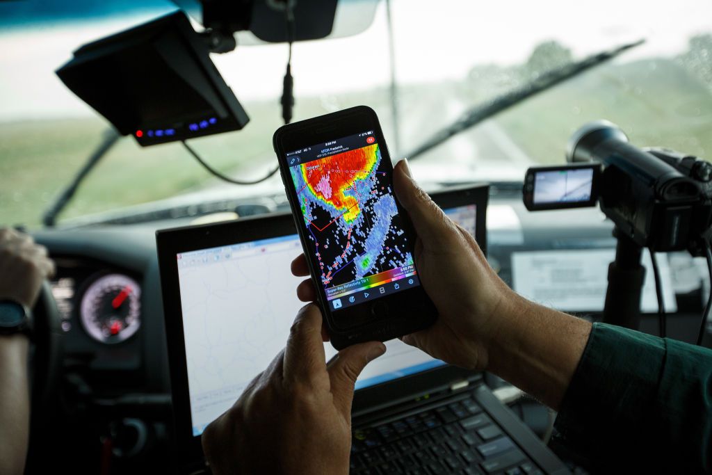
The Weather Channel is one of the most popular weather services in the world, and they have a free app called Storm Radar that will help you keep track of hurricanes and other severe weather.
Storm Radar is a free app from The Weather Channel that lets you see exactly where any tropical storm or hurricane is moving, and it’s incredibly easy to use. The app has been around for years, but only recently received an update with new features like lightning tracking and full-screen mode.
From there, you can see the hurricane’s trajectory and when it’s expected to arrive in your area. You can zoom in on specific areas to get even more detailed information about how far away from your house the hurricane might be. For example, here are a few snapshots from inside the app:
2. Hurricane by American Red Cross: Track Your Loved Ones
The American Red Cross hurricane tracker is a free app that allows you to monitor the location of your loved ones and see how safe they are during a hurricane. The app is available for both iOS and Android devices.

The American Red Cross has a number of disaster preparedness apps that can help you get ready for hurricanes and other extreme weather events. These apps are designed to help you prepare for the worst-case scenario, but also give you peace of mind by showing how much time you have before it hits.
One of these apps is Hurricane, which gives you an overview of what to expect during a hurricane as well as ways to stay safe if you’re already in the middle of one. The app also allows you to track people’s locations so that they can be assured they’re safe during dangerous storms.
The first page of the app shows a map of where the storm is currently located and how close it is to any major cities nearby. You can tap on any city name to see its current weather conditions, which include wind speed, temperature, and humidity levels. The next section shows a list of cities that are likely to get hit by the storm and their current status (either “Prepare Now” or “Prepare Later”). The last section gives information about how far away from land the hurricane is at any given moment — whether it’s over land or in open water — as well as how fast its winds are going.
3. My Hurricane Tracker: An Easy-to-Use Hurricane Tracker
My Hurricane Tracker is a free app that lets you easily track storms as they move across the Atlantic and Caribbean.
The app features beautiful graphics and an easy-to-use interface that provides all the information you need to stay safe while a storm is
approaching.
You can use the free version of my Hurricane Tracker: An Easy-to-Use Hurricane Tracker to track hurricanes. The app lets you see the path of the hurricane from when and where started, where it’s at right now, and its forecasted destination. Just tap the little hurricane icons on the map for more detail.
It’s the time of year when we start getting those first hurricane threat alerts. The app is designed to be easy to use and quick to load, so you can get up-to-date information on storms as soon as it’s available.
- Clime: Detailed Maps and Offline Tracking
Clime is not just for hurricanes — it also lets you track extreme weather events like tornadoes and wildfires.

Clime also has a radar map that shows you where storms are currently located. If there’s one nearby, it’ll show up on your list of saved locations. The app’s biggest strength is its ability to track storms even when there’s no internet connection. It caches the map animations, forecasts, and alerts so that even if you don’t have access to the internet, you can still see the most recently downloaded information.
The app has an extensive list of weather data that includes current conditions, hourly forecasts, historical data, and more. It also has a full list of severe weather alerts that can tell you when a storm is on the way.
There are several ways to use Clime: You can open the app directly from your device’s home screen or download it from the App Store or Google Play store. If you’re interested in hurricane tracking, then we suggest downloading it directly from a browser on your computer or phone so that you can set up all of your saved locations ahead of time instead of having to do it all manually when there’s no power during a storm.
5. Ventusky: Super Detailed Wind Patterns

The most unique thing about Ventusky is that it provides a detailed visual representation of wind patterns. It’s not just a map with arrows showing the direction of the winds; it shows the actual wind speed and direction in which they’re moving.
The map itself is interactive so you can zoom in or out as needed to focus on your area of interest. You can also click on individual storms to
get more detailed information about them.
You can also zoom in on individual cities or countries to see what’s going on in real-time. There are options for different modes too — such as satellite mode or radar mode — depending on how much detail you want to see. The maps are updated every 10 minutes so they’re incredibly accurate!
There are several different themes available including satellite imagery with historical data overlaid on top of it. This makes it easier to see how things have changed over time as well as what’s coming up next.
-MoMo